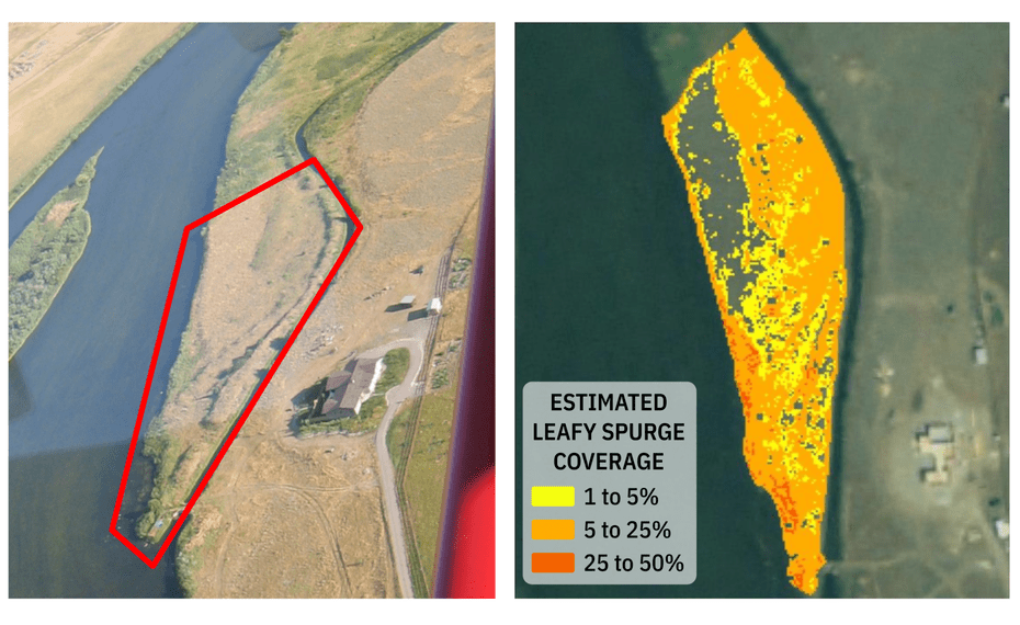

Using Hyperspectral Imaging to Identify Invasive Weeds
Managing invasive weeds starts with locating them, which is difficult across acres of pasture. Hyperspectral imaging made this possible.
$18M
Annual impact of leafy spurge35
Test sites used to train algorithm95%
Identification accuracy
Annual impact of leafy spurge35
Test sites used to train algorithm95%
Identification accuracy
In Montana alone, leafy spurge is estimated to impact the state’s economy by $18 million per year. A group of student researchers at Montana State University were looking for an economical way to identify the location of leafy spurge to begin the process of eradication. This research involved determining the optimum time for detecting the plant (June) and how to determine the boundaries of the infested site in a pasture or rangeland. The team used Resonon’s hyperspectral imager to capture information from 35 different test sites over a period of seven weeks to train their random forest model.
Challenge
Accurately identify and locate areas of leafy spurge, a noxious perennial weed, over large areas of rangeland in a timely and cost-effective manner.
Since appearing in the United States in the 1800s, leafy spurge has invaded large pastures, grasslands, prairies, and rangeland. It’s particularly harmful for cattle ranchers because its presence can negatively impact livestock carrying capacity. Managing invasive weeds starts with locating them, which is difficult across acres of pasture.
Solution
Resonon’s hyperspectral imagers provide the instrumentation and methodology for distinguishing between noxious weeds and the grass and shrubs surrounding them. They are portable enough to mount on drones and provide accurate image and location data over large swaths of land.
Equipment Used
Because this research site was difficult to access using motor vehicles, the team chose Resonon’s Field System with the Pika II (the predecessor to the Pika L) hyperspectral camera for their research. This camera is ideal for fieldwork because it offers high resolution in a portable, cost effective, easy-to-use system. The research team noted that the data quality coming from the Pika II was comparable to more expensive systems.

Results
The students were able to identify leafy spurge with 95% accuracy, distinguishing it from other plants such as grasses and sagebrush. The initial study was performed at ground level, but it’s now the foundation for an aerial methodology. A Pika camera mounted on a drone can cover a considerably large amount of terrain in a reasonable amount of time.
Download the full case study or see all precision agricultural application examples.
Download the full case study or see all precision agricultural application examples.
Contact us
Contact usMore Case Studies
Contact Us
Click below and our hyperspectral experts will contact you soon.
Complete Hyperspectral Imaging Solutions
Contact
Resonon Inc.123 Commercial Drive
Bozeman, MT 59715 USA
